

BMW Maps Gets a 3D View Showing How BMW Sees the Road
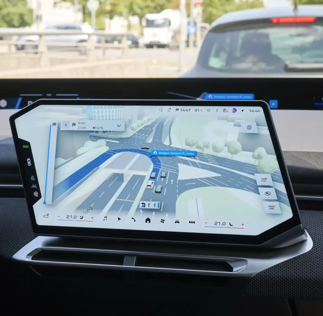
BMW is changing the way drivers can see what their car detects on the road. From October 2026, selected BMW models equipped with BMW Operating System X will introduce a new version of BMW Maps that combines traditional navigation with a three-dimensional representation of the vehicle’s surroundings.
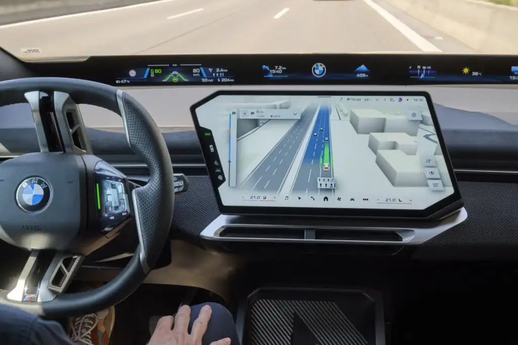
Instead of showing only the route and upcoming navigation instructions, BMW Maps with Driver Assistance can also visualize how the vehicle perceives the road around it. BMW says the new approach brings navigation, environmental perception and driver assistance together in a single 3D view.
BMW Maps Combines Navigation and Driver Assistance
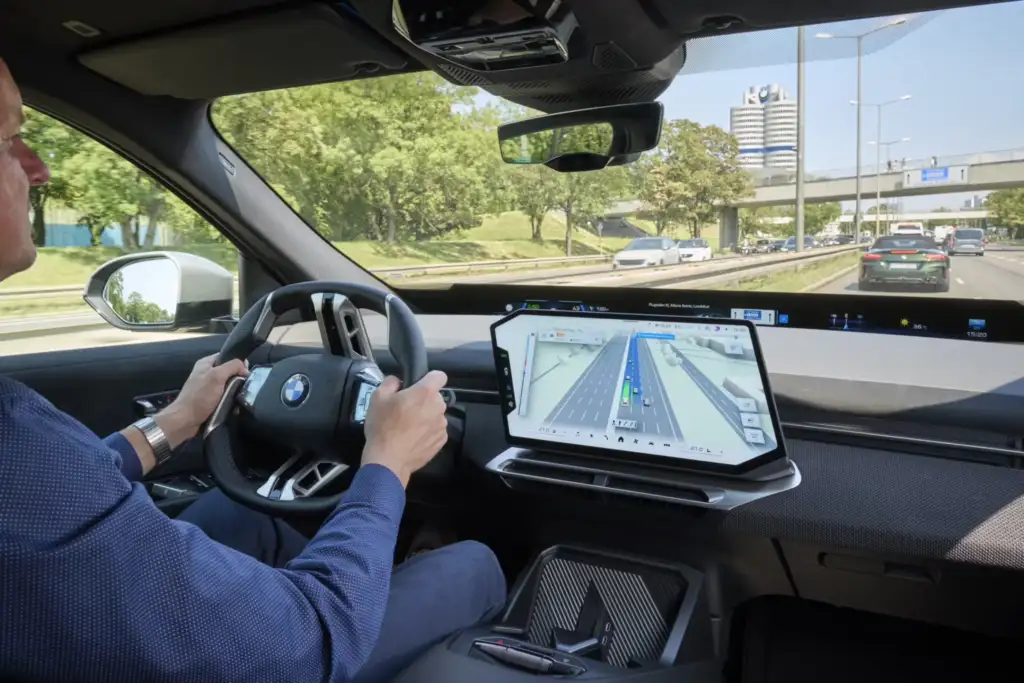
Until now, navigation information and driver assistance data have largely been presented as separate elements of the driving experience. The new BMW Maps experience is designed to bring them together on the central display.
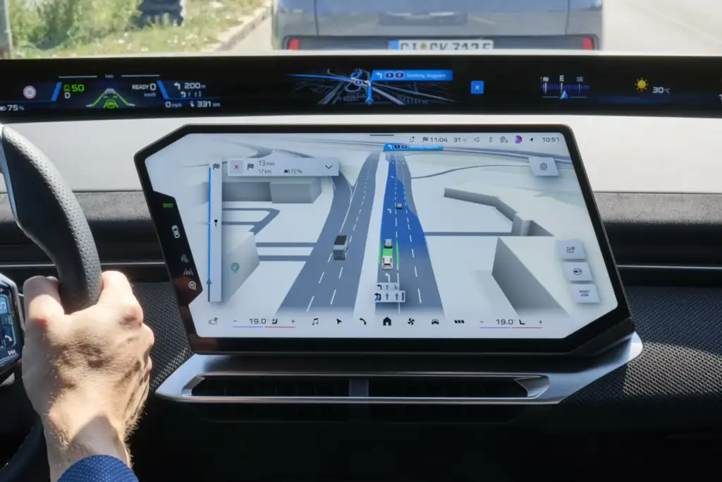
The vehicle is shown in its actual lane and at the correct level of the road, which can be particularly useful at complex junctions, multi-level intersections, flyovers and large highway interchanges.
The 3D visualization can also show surrounding vehicles and other elements detected by the vehicle’s driver assistance systems.
This is not a live camera feed or a raw display of radar data. Instead, the system creates a digital representation of the environment as interpreted by the vehicle and combines it with navigation information.
A 3D View of the Road Around the BMW
Editor’s Choice
The idea behind the new interface is relatively simple: as driver assistance systems become more capable, drivers need to understand what the vehicle is detecting and how it is responding to the situation around it.
On a complicated interchange, the 3D view can make it easier to understand which lane the BMW is traveling in and how the road is structured. On highways, the driver can see surrounding vehicles detected by the system and how the vehicle is positioned relative to them.
Rather than simply adding another visual layer to BMW Maps, BMW is combining navigation, environmental perception and driver assistance into one interface.
Highway Assistant 2 Enables Hands-Free Driving
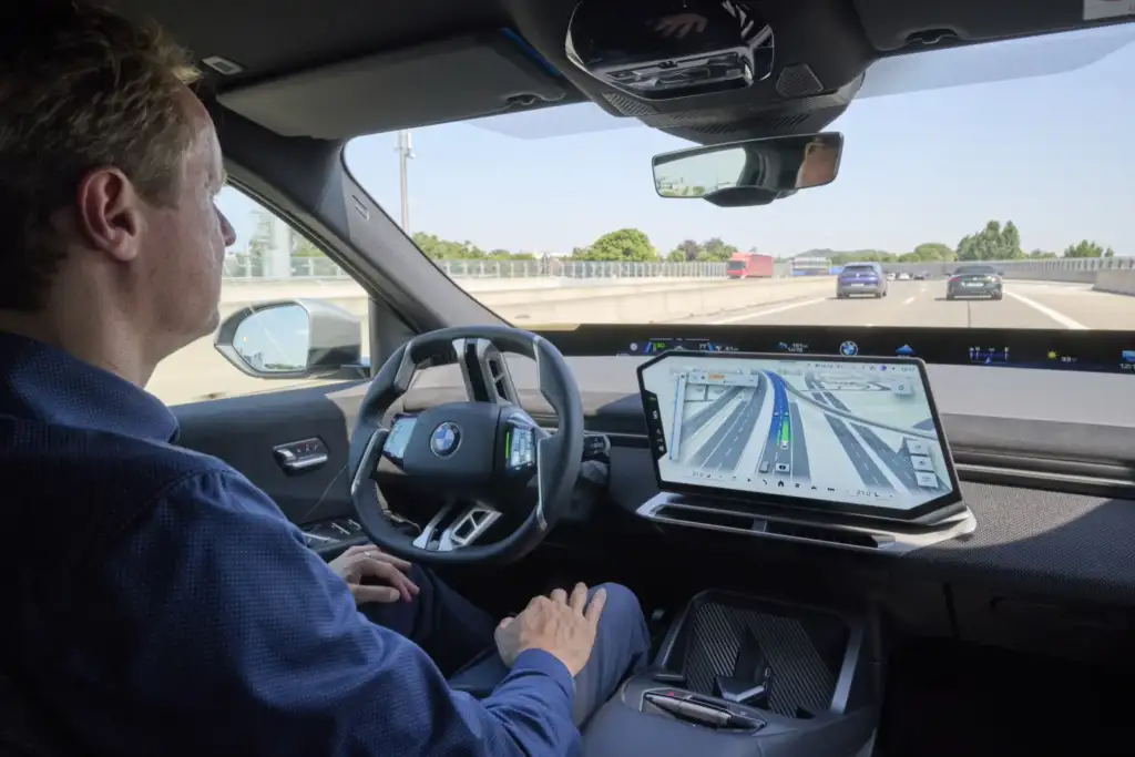
The new BMW Maps experience is particularly relevant to BMW’s more advanced driver assistance systems. One of them is Highway Assistant 2, which can enable hands-free driving on suitable highways at speeds of up to 130 km/h when the vehicle is appropriately equipped.
The system can control the vehicle’s longitudinal and lateral movement and support automatic lane changes.
READ MORE: BMW Neue Klasse Can Stop You Opening the Door Into a Cyclist
One of the more unusual features is the way a driver can confirm a lane-change maneuver. A brief glance toward the appropriate exterior mirror can signal the driver’s intention. The vehicle then analyzes the surrounding traffic and, if the conditions allow, can perform the lane change.
When combined with navigation-guided driving, these functions can allow the BMW to handle much more of a highway journey with limited driver input.
What Will Drivers See on the Screen?
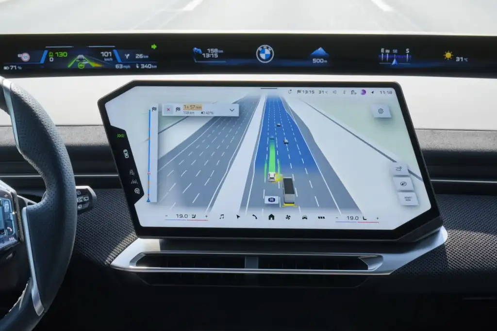
Depending on the vehicle, equipment and available functions, the new BMW Maps view can display:
- the vehicle’s position in the correct traffic lane,
- the road and lane layout,
- vehicles detected around the BMW,
- roads and junctions at different levels,
- information related to active driver assistance functions,
- navigation instructions integrated with the surrounding traffic situation.
This means BMW Maps becomes more than a conventional navigation interface. It also becomes a visual communication layer between the driver and the vehicle’s perception systems.
BMW Maps Uses Vehicle Sensors, AI and Mapbox
The new visualization combines several sources of information. BMW uses data collected by the vehicle’s sensors together with artificial intelligence, navigation data and mapping technology to create the 3D representation.
An important part of the system is BMW’s cooperation with Mapbox, a company specializing in digital mapping and navigation technologies.
BMW says the overall integration was developed by engineers within the BMW Group. The goal is to combine route information with the real-world situation detected by the vehicle and present the two in a consistent way.
In practical terms, this allows the navigation system and driver assistance functions to communicate the vehicle’s understanding of the road through a single visual interface.
BMW Is Bringing Navigation-Guided Driving to Cities
Highways are not the end of BMW’s plans. From 2027, BMW says it will gradually expand navigation-guided, partially automated driving functions to urban areas.
The rollout is initially planned for Germany, with availability depending on the vehicle, equipment, market and applicable regulations.
City driving could make this integration even more important. Urban environments contain significantly more variables than highways, including intersections, multiple lanes, pedestrians, cyclists and changing traffic conditions.
Combining navigation data with the vehicle’s perception of its surroundings could therefore become an important part of BMW’s approach to more advanced driver assistance in urban environments.
When Will BMW Maps with Driver Assistance Launch?
BMW plans the first rollout of the new BMW Maps experience for October 2026.
The feature will be available on vehicles equipped with BMW Operating System X and the appropriate driver assistance technology. Depending on the market and vehicle, this can include Highway Assistant or Highway & City Assistant.
Availability will also depend on vehicle equipment, local regulations, homologation and the roads supported by the system.
As a result, having BMW Operating System X alone does not automatically mean that a vehicle will receive every function described here.
Why BMW Maps’ New 3D View Matters
The most interesting part of BMW’s new system is not the 3D graphics themselves. The bigger change is the attempt to make increasingly complex driver assistance systems easier for drivers to understand.
The more tasks a vehicle can perform automatically, the more important communication between the car and the driver becomes. A unified 3D view can provide a clearer explanation of what the vehicle detects and how it understands the current road situation.
It also represents another step toward a cockpit where navigation, safety systems and driving automation are no longer presented as completely separate functions, but as parts of one digital driving environment.
FAQ
When will BMW Maps with Driver Assistance be available?
BMW plans the first rollout of the new BMW Maps experience for October 2026.
What is BMW Maps with Driver Assistance?
It is a new way of combining navigation and driver assistance information in a single 3D view. Depending on the vehicle and available functions, drivers can see their BMW, lane positioning, surrounding vehicles and other elements detected by the vehicle.
Does BMW Maps show the camera feed from the car?
No. It is not a conventional camera-view system. Instead, BMW Maps creates a digital representation of the vehicle’s surroundings based on information detected and interpreted by the vehicle’s systems, combined with navigation data.
How fast can BMW Highway Assistant 2 operate?
On suitable highways and in appropriately equipped vehicles, Highway Assistant 2 can enable hands-free driving at speeds of up to 130 km/h.
Will BMW Maps with Driver Assistance be available in every BMW?
No. The functionality is linked to vehicles equipped with BMW Operating System X and the required driver assistance systems. Availability also depends on the market, vehicle equipment, regulations and supported roads.
Will BMW introduce navigation-guided driving in cities?
BMW plans to gradually expand navigation-guided, partially automated driving functions into urban areas from 2027, initially in Germany. Availability will depend on the vehicle, market and applicable regulations.
